A playful way to defend your homeland – military cartography in Zurich
Wars in the east reveal that the Swiss military is behind the times, with many Zurich-based officers believing that they need to fill gaps in their own military intelligence. No, we’re not talking about current events, but about a time more than 250 years ago.
Zurich’s military geographers at the Mathematical-Military Society

In 1765, 10 officers from Zurich founded a society for the joint study of foundational technical and mathematical subjects – including improved military cartography. This Mathematical-Military Society (Mathematisch-Militärische Gesellschaft) visited a section of Zurich’s border each year in order to study its military geography. As a result, the border region was thoroughly re-surveyed between 1787 and 1792. The volunteers’ (!) work was carried out under the supervision of the (military) engineer Johannes Feer (1763–1823), who had trained abroad.
A handwritten nine-page border atlas was created in 1795 by society member and cartographer Hans Caspar Hirzel (around 1774–1818). It also includes a 20-page list of landmarks. Considering the small number of people involved, the result is astonishing. Duplicating the map was forbidden for reasons of confidentiality.
Simulation games on the ‘Siegfried map’

The Swiss Federal Staff Office published the ‘Topographische Atlas der Schweiz’ (‘Topographic Atlas of Switzerland’, also known as the ‘Siegfried map’) from the 1870s onwards. Suddenly, large-scale maps of the whole of Switzerland were available to the general public. This made the Mathematical-Military Society’s secret cartographic archive surplus to requirements. In 1882, it was donated to the non-military ‘Kartenverein’ (‘map association’), adding a hefty 379 maps to the club’s collection. The map association was dissolved 12 years later and the maps were transferred to the Stadtbibliothek, a predecessor of what is now the Zentralbibliothek Zürich.
In the winter months, officers in Zurich and Winterthur occupied themselves with the ‘war game’ – a term simply unimaginable today – in which staff officers played simulation games on maps as part of their tactical training. Initially, sheets of the ‘Siegfried map’, glued together, were used for this.
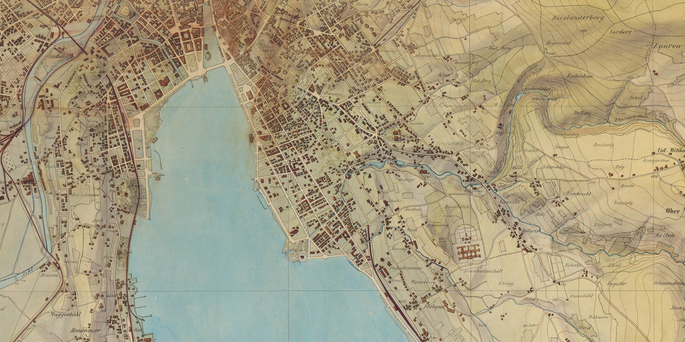
Bigger, more sculptural, more colourful: Captain Andreas Hefti’s simulation game maps

A war game map by Captain Andreas Hefti, 1895/96. (Image: ZB Zürich)

An excerpt from the map: the Lake Zurich basin. (Image: ZB Zürich)

An excerpt from another of Hefti’s war game maps: Wipkingen, Unterstrass, Oberstrass…

…Seebach, Oerlikon, Schwamendingen and Wallisellen. (Image: ZB Zürich)

The Gubrist and the Werdinsel, among other sites, are depicted on a third of a total of 24 war game manuscript maps.
(Image: ZB Zürich)

The terrain shading on Andreas Hefti’s maps really comes into its own on areas of elevation. The Uetliberg and Fallätsche can be seen on the right in this excerpt. (Image: ZB Zürich)

The city of Winterthur can also be found on the war game maps…

… as can Kloten, today home to the airport. (Images: ZB Zürich)

At Rheinau, Hefti’s terrain shading illustrates the different topography on both sides of the Rhine. (Image: ZB Zürich)

The Irchel, near Berg am Irchel, is also shown off to full effect. (Image: ZB Zürich)
There was an issue with these officers’ simulation games, though: the scale of 1:25.000 made it difficult for bystanders to recognise details and names from a distance. To resolve this, Captain Andreas Hefti (1862–1931) created the enlarged and exceptionally beautiful 1:10,000 relief maps of the canton of Zurich based on the Siegfried map from 1895 onwards, as Arthur Dürst explains. Thanks to the new shading of the terrain, it was possible to visually identify the topography, which was important for the course of the manoeuvre, from a distance.
We can imagine how the men gathered around the maps laid out on the tavern floor, engaging in lively discussions. Mind you, the combined map took up about 15 square meters. On closer inspection, you might even be able to spot a small red wine stain here and there.
Of the original 28 hand-drawn sheets, 24 were preserved in good condition over the century or so during which the map was in private possession. Hefti’s ‘war game maps’ have been held in the Zentralbibliothek Zurich’s map collection since 2017.
Looking beyond the national borders – South Africa as a theatre of war

Zurich-based officers also cast their gaze abroad, with the aim of broadening their tactical horizons. While the Second Boer War (1899–1902) raged in South Africa, this was followed with great interest in Europe. In many ways, this conflict accelerated the transition from traditional warfare techniques to modern approaches. In addition, deliveries of German arms to the Boers led to geopolitical tensions between the German Empire and the British Empire, which in turn revealed its imperialist ambitions in Africa.
To provide an overview of the situation, Captain Hefti compiled a large map, which was published in Zurich in 1900 (with an ancillary map of Switzerland as a reference). The copy in the Zentralbibliothek still bears the author’s handwritten dedication to Commander Hermann Bleuler dated 20 November 1900.
The clearness of the topological relief was of particular importance for understanding the course of the war, with the experience gained from Swiss mountain cartography – a skill valued around the world – put to good use here.
Military maps of Zurich from earlier times

Zurich’s ‘city quarter’ on a military quarter map from 1660, copied by hand in 1735. This recruitment area for the armed forces in the city of Zurich extends beyond current municipal boundaries. (Image: ZB Zürich)

The city of Zurich and the surrounding area, which were even less densely populated at the time. (Image: ZB Zürich)

‘Dess Wintterthurer-Quartiers, samt der anstossenden Turgowischen Landen, und anderer Quartieren Zürichgebiets eigentliche Verzeichnus’ (‘A directory of the Winterthur quarter, including the adjoining Thurgau lands, and other quarters in the Zurich area’): a manuscript map from the same series, dating 1660 and 1735. (Image: ZB Zürich)

This section shows Winterthur, Oberwinterthur and Töss, amongst others. Kyburg is located on the right-hand side of the image. (Image: ZB Zürich)

‘Dess Wädenschwyler Quartiers eigentliche Verzeichnus, samt anderen nechstanstossenden Quartieren, und Landschafften’ (‘A directory of the Wädenschwyler quarter, along with other adjoining quarters and landscapes.’) (Image: ZB Zürich)

‘Dess Turbenthaler Quartiers, samt anderer Quartieren anstössen eigentliche Verzeichnus’ (‘A directory of the Turbenthal quarter, along with other adjoining quarters’). (Image: ZB Zürich)

Lake Pfäffikersee can also be seen on the Turbenthal map. (Image: ZB Zürich)

An excerpt from Hans Conrad Gyger’s map of the Zurich area from 1667, copied by hand in 1763 by Johannes Müller.
(Image: ZB Zürich)

At that time, the Sax-Forstegg estate was a Zurich governorship and exclave. Today, the area belongs to the canton of St. Gallen. (Image: ZB Zürich)

Stein am Rhein also belonged to Zurich. (Image: ZB Zürich)

Winterthur and surroundings. The areas marked in yellow represent vineyards. (Image: ZB Zürich)

The boundary between Zurich and Schwyz at Frauenwinkel and at Bächiwinkel on Lake Zurich near Rapperswil was long disputed. The ‘Tagsatzung’, or council, even had to mediate in the matter from 1766–1796. (Image: ZB Zürich)

Zurich, also with numerous vineyards. The fortress is clearly visible. (Image: ZB Zürich)

The creators of the map are listed in the lower right corner. (Image: ZB Zürich)
However, the discipline of military cartography in Zurich did not begin in 1765 with the founding of the Mathematical-Military Society: it was already more than a century old by that point. From 1644 to 1660, Hans Conrad Gyger (1599–1674) produced 10 maps of the Zurich countryside under the impact of the Thirty Years’ War, with the troop assembly sites and their recruitment areas marked. At the same time, he spent more than three decades working on a large hand-painted relief map of the Zurich area. This masterly sculptural representation of the terrain could not be published for a long time due to military secrecy requirements.
Both maps are held by the State Archives. Handwritten copies of these military quarter maps and the cantonal map, dated a few decades later, have been preserved at the Zentralbibliothek. Most of them are by other key cartographers, such as Johannes Müller (1733–1816), who in turn is responsible for key milestones in the history of surveying.
A map from Zurich for a Swedish general

Hans Conrad Gyger did not only map the area around Zurich: before the Mathematical-Military Society existed, he also created a map of the Lake Constance region. Unlike Hefti’s military map of South Africa, however, the Lake Constance map did serve as an aid in the war. Gyger created it – with the blessing of the Zurich authorities – during the Thirty Years’ War for the Swedish General Count Gustav Horn (1592–1657). The map has an approximate scale of 1:50.000 and the cartographer completed work on it in 1633, as the Zurich-based cartographic historian Samuel Wyder discovered.
General Horn passed through the Common Lordship of Thurgau and besieged the city of Constance from the Swiss side. His army plundered the castles at Neuhorn and Romanshorn and partly destroyed them. Winterthur supported the campaign by providing food and black gunpowder. Gyger’s map of Lake Constance survived the campaign and entered the Zentralbibliothek Zürich’s map collection from private Swedish possession 20 or so years ago.
Dr. Jost Schmid-Lanter, Head of Map Departement
July 2024
Header image: Excerpt from a war game map by Captain Andreas Hefti, 1895/96. (ZB Zürich)